
Philippines Weather When To Go (2026): Monsoon & Typhoon Season
The monsoon and typhoon season in the Philippines follows a yearly cycle, so what does this mean for visitors, and when is the best time to go? The typhoon season typically stretches from June to December, but does this mean we have to deal with wind, rain and disruption for six months of the year? Certainly not. The impact of these weather systems is regional. The upper parts of the country, Luzon, will see impacts from June to September, while the Visayas and Mindanao will see impacts from October to December. Of course, it is not an exact science, but it does allow travellers to plan their visits around the regions, not just the country, and hopefully keep dry and warm along the way.
In this article, we look at how these weather systems are classified and managed, when and where they are most likely to strike, what drives their formation, and the real impact they have on daily life and infrastructure here in the Philippines.

Table of Contents
Click a topic below to jump directly to that section of the guide.
2.PAGASA Area of Responsibility
4.The Typhoon Season - It's Regional
5.The Perfect Storm – Forces & Factors

Explore Our Hub Pages, Plus We Take A Close At Look Finance & Managing Your Healthcare
Our three hubs bring the site together, making it easy to navigate and find the articles that matter to you. Keep Reading More Here — Health and healthcare essentials, what matters and for every budget, plus we focus in on finance, including working opportunities.


Tropical Cyclone Categories in the Philippines
In the Philippines, tropical cyclones are classified by the Philippine Atmospheric, Geophysical and Astronomical Services Administration (PAGASA) based on maximum sustained winds. These categories describe the likely strength and impact of each system, from weak tropical depressions to destructive super typhoons.
| Category | Maximum Sustained Winds | Description | Typical Impact |
|---|---|---|---|
| Tropical Depression (TD) |
≤ 61 km/h ≤ 38 mph |
Weak, short-lived system producing light to moderate rain. | Minor flooding in low areas; little to no structural damage. |
| Tropical Storm (TS) |
62–88 km/h 39–55 mph |
More organized storm with stronger winds and heavier rain. | Localized flooding, light damage to weak structures; travel delays. |
| Severe Tropical Storm (STS) |
89–117 km/h 55–73 mph |
Larger, more intense system with sustained damaging winds. | Tree and light roof damage, power interruptions, coastal flooding. |
| Typhoon (TY) |
118–184 km/h 73–114 mph |
Strong cyclone capable of widespread destruction. | Roof failures, downed lines, storm surge in exposed coasts. |
| Super Typhoon (STY) |
≥ 185 km/h ≥ 115 mph |
Exceptionally intense storm. | Severe structural damage, life-threatening surge, prolonged outages and recovery. |

The Philippine Area of Responsibility (PAR)
The Philippine Area of Responsibility, or PAR, is the section of the western Pacific Ocean where the Philippines officially monitors tropical cyclones under the supervision of PAGASA. When a storm enters this zone, PAGASA begins issuing bulletins and forecasts, and assigns the system a local storm name, which is used in public warnings and advisories to keep communities informed of potential impacts.
Getting Typhoon Alerts
Mobile Phone: Alerts in the Philippines are automatic government warnings sent through the national cell broadcast system. Messages from the National Disaster Risk Reduction and Management Council (NDRRMC) or PAGASA give short updates on storm position, wind signals, and urgent advisories.
Social Media: Official updates are posted through PAGASA’s verified channels, including their Facebook and Twitter pages linked below.

Follow PAGASA’s official Facebook page for real-time forecasts and storm bulletins from the national weather bureau.

Get live updates, rainfall warnings, and storm tracking posts from PAGASA’s official Twitter feed.

Typhoon Season in the Philippines
The typhoon season in the Philippines generally runs from June to early December, although tropical cyclones can form at any time of the year. The most powerful systems — such as Yolanda (November 2013) and Odette (December 2021) — struck late in the year, when warm seas combined with La Niña conditions to fuel exceptionally destructive super typhoons.
Throughout the year, cyclone tracks in the Philippines follow a pattern shaped by the monsoon. From June to September, storms form in the Pacific and move northwest across Luzon. As winds turn northeast from October to December, their paths shift southward, bringing late-season landfalls to the central and southern islands.
Regional and Seasonal Typhoon Patterns
The table below shows how the timing of the monsoon influences where tropical cyclones most often form and which regions of the Philippines are typically affected.
| Months | Dominant Monsoon | Season Type | Main Cyclone Tracks | Regions Most Affected |
|---|---|---|---|---|
| January – May | Northeast Monsoon (Amihan) | Cool Dry Season | Occasional early systems forming far east; few make landfall | Bicol Region, Eastern Visayas, Northern Mindanao (rare) |
| June – September | Southwest Monsoon (Habagat) | Rainy Season | Storms track northwest across the Pacific toward Luzon and the northern Visayas | Northern Luzon, Bicol Region, Northern and Eastern Visayas |
| October – December | Northeast Monsoon (Amihan) | Cool Wet Season | Storm paths shift southward, crossing the central islands and parts of Mindanao | Central Visayas, Eastern Visayas, Northern Mindanao |
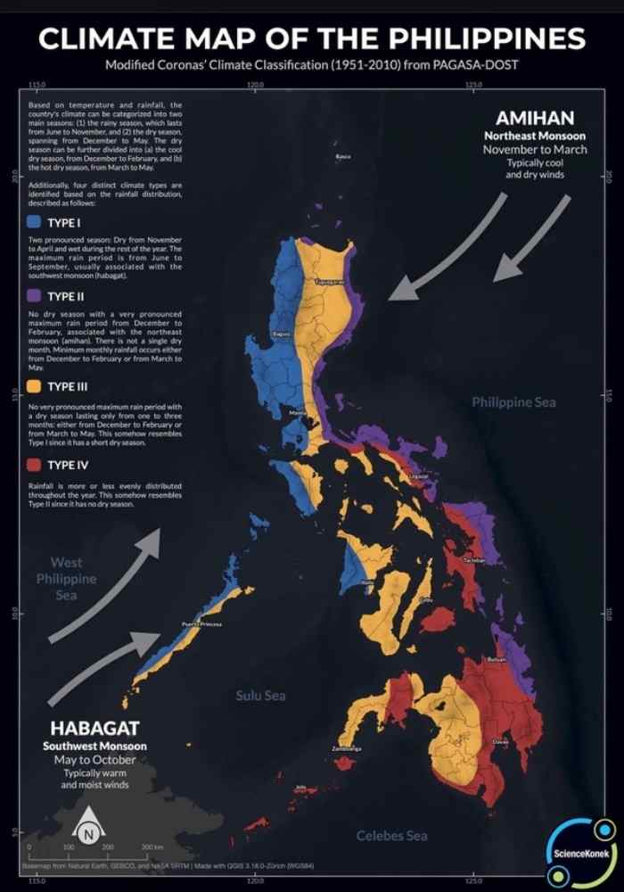
Amihan & Habagat Seasonal Monsoon Pattern
The ilustration shows the monsoons paths and time lines. It is normal for the monsoon seasons to change every year, you can expect the Habghat to become active March/May and the Amihan to become active October/November.

The Perfect Storm – Forces & Factors
A powerful typhoon forms when key conditions align: Sea temperatures above 26 °C supply heat and moisture, monsoon winds add humidity and help steer the system, and La Niña often enhances moisture flow while creating more favourable wind conditions. Together, these forces create the warm, stable environment that allows a tropical disturbance to grow into a severe storm.
Main Influencing Factors
The table below outlines the key elements that affect tropical cyclone behavior in the western Pacific.
| Factor | Description | Main Effect on Typhoons |
|---|---|---|
| Warm Ocean Temperatures | Sea surfaces above about 26 °C provide the heat and moisture that power tropical systems. The surrounding seas reach their highest temperatures from May to July, storing energy that fuels cyclone growth through the main typhoon season. | Supplies the energy that drives storm formation and determines how intense a system can become before landfall. |
| Monsoon Winds | Seasonal wind shifts — the southwest monsoon (Habagat) and northeast monsoon (Amihan) — change airflow and humidity across the region. Habagat brings warm, moist air and heavy rain from June to September, while Amihan brings cooler, drier air from October onward. | Influence where storms form, how they move, and which areas of the country are most affected during each season. |
| El Niño–Southern Oscillation (ENSO) | ENSO is the natural cycle of warming (El Niño) and cooling (La Niña) in the equatorial Pacific. During El Niño, sea-surface temperatures rise in the central and eastern Pacific, weakening the trade winds and shifting storm formation eastward, away from the Philippines. La Niña has the opposite effect, cooling the same region and strengthening winds that carry more moisture toward the country. | During El Niño years, fewer typhoons form near or cross the Philippines. During La Niña, more systems develop closer to the islands and are often stronger due to increased moisture and favorable wind patterns. |
For up-to-date information: See PAGASA’s official ENSO monitoring page on current El Niño and La Niña conditions.
Check the latest ENSO status from PAGASA for live updates on El Niño, La Niña, and their impact on the Philippines’ weather.

National Impact of Typhoons
Major typhoons have left a deep and lasting impact on the people of the Philippines. These disasters are compounded by the country’s complex logistics — thousands of islands, limited transport routes, and infrastructure that is often damaged during storms. Moving relief goods, restoring power, and reaching isolated communities can take weeks, making coordination between national and local agencies critical to any recovery effort.
Typhoons also have a measurable effect on the national economy. Major storms can cause losses equal to one or two percent of annual GDP, with agriculture, housing, and transport taking the hardest hits. Damage to crops and supply routes raises food prices, while reconstruction costs strain both local and national budgets. Although the economy usually rebounds within months, repeated storms slow long-term growth and increase public spending on recovery and infrastructure repair.
Typhoons in the Philippines will continue to shape the nation and the lives of its people. Yet steady economic growth, better housing, and stronger local governance are slowly improving resilience. Modern construction standards, expanded power grids, and wider access to communications mean more communities can prepare, respond, and recover faster than in the past. While storms remain a fact of life here, the country’s growing capacity reflects real progress towards a more stable future.

Living with Typhoons – Final Thoughts
During my time living in the Philippines, yearly weather conditions have consistently varied from one year to the next. These seasonal differences are strongly influenced by larger climate patterns, particularly El Niño and La Niña. During 2023–2024, an El Niño–influenced period, my region experienced prolonged hot and dry conditions with very limited storm impact. By comparison, 2025 has been shaped by La Niña conditions, bringing more unsettled weather, heavier rainfall, and more frequent impacts from tropical systems.
From my own experience, and particularly for those coming to the Philippines to travel or on holiday, it’s rarely necessary to plan too rigidly around the weather. That said, having a clearer understanding of the science behind the seasons makes it easier to think about which regions may be better suited to visit at different times of the year, without losing the flexibility that makes travel here enjoyable.
Explore The Sites Hub Pages & Selected Articles
Our three hub pages form the foundation of the site, covering long-term living in the Philippines, diving across the country, and the society that shapes everyday life. Beneath them are selected dive articles that go deeper into specific locations and equipment, offering practical insight into what diving in the Philippines is really like.


Frequently Asked Questions
When is typhoon season in the Philippines?
The main typhoon season generally runs from June to early December, although tropical cyclones can form at any time of year. The most powerful and destructive systems often occur late in the season, particularly from October through December.
How many typhoons affect the Philippines each year?
On average, around 20 tropical cyclones enter the Philippine Area of Responsibility each year. Of these, roughly 8 or 9 either make landfall or cause significant impacts through heavy rain, strong winds, or coastal flooding.
What is the Philippine Area of Responsibility (PAR)?
The Philippine Area of Responsibility is the section of the western Pacific Ocean where the Philippines monitors tropical cyclones. When a system enters this area, local bulletins, forecasts, and a Philippine storm name are issued to inform the public.
Which parts of the Philippines are most affected by typhoons?
The regions most affected depend on the season. Northern Luzon and the Bicol Region are more commonly impacted mid-year, while the central and southern islands face higher risk later in the year as storm tracks shift south.
How do El Niño and La Niña influence typhoons in the Philippines?
El Niño conditions usually bring fewer typhoons near the Philippines and hotter, drier weather. La Niña tends to increase rainfall and allows more storms to develop closer to the country, often leading to more frequent and impactful seasons.
Do typhoons affect daily life in the Philippines year-round?
No. Typhoons are seasonal rather than constant. Many months pass with little or no storm impact, and conditions can vary greatly from year to year depending on broader climate patterns.
© 2025 Live Life The Philippines. All rights reserved.
Back to Top